
-
Duke Energy Weekend Update
It looks like we may have a winter wonder land this weekend. Snow is in the forecast for our entire service area but luckily it is predicted to be light and powdery which does not pose a significant threat to our infrastructure. Below is the latest weather update from Duke Energy meteorologists but, as always, the National Weather Service is your official provider of weather information.
FORECAST
Today, skies start off partly sunny, then increasing clouds will develop into the afternoon as the winter storm system approaches. Rain showers may start overnight before changing over to snow on Saturday. Lows will be in the 20’s with highs in the middle 30’s to near 40 degrees. Tomorrow and Sunday, we may see wind gusts.
Confidence is increasing for a snow event to impact portions of the Carolinas this weekend. Forecast models are gradually trending snowier for parts of central and eastern Carolinas coupled with gusty winds and bitter cold. As of this morning:- High snow ratios will likely create a large swath of 3-8” of accumulating snowfall over a wide area of the service area.
- We’re confident this would be a mainly snow event; ice is not expected. The snow will be mainly a dry/powdery snow (light enough to blow with a leaf blower).
- Blustery winds increase Saturday afternoon to Sunday.
- Travel may be severely hindered Sunday to Monday depending on snow amounts.
- It will be bitter cold Saturday to Monday morning
The extended forecast shows that Sunday evening through Monday morning will be very cold with possible lows in the upper single digits to middle teens and will be dependent on snowfall. Snow cover may linger through the middle of next week as temperatures remain very cold overnight causing multiple occurrences of freeze/melt/refreeze. Temperatures will warm toward freezing Wednesday – Thursday as models suggest the next storm system passes through with highs in the 40’s, then a bit colder into next weekend.
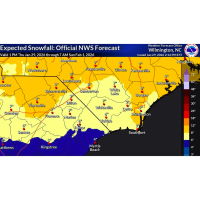
Below is a map from the National Weather Service:
Prolonged below-normal temperatures are pushing home energy use higher across the Carolinas – and this can mean higher bills. Duke Energy is sharing practical steps to help customers manage costs during this cold stretch.
Here are some tips to help save on your power bill; small actions can add up:- Set your thermostat to the lowest comfortable setting.
- Seal leaks and insulate to keep warm air inside.
-
Let the sun help heat your home by opening blinds and curtains during the day and closing them at night.
-
Operate ceiling fans clockwise to push warm air down.
Lauren Griggs
Duke Energy
District Manager-Government and Community Relations
Chesterfield, Darlington, Dillon, and Marlboro Counties C: (803) 229-0531
Duke Energy
-
Lauren Griggs
- January 30, 2026
- (800) 452-2777
- Send Email
